
NCERT Solutions Class 9 Social Science (Geography – Contemporary India – I)
The NCERT Solutions in English Language for Class 9 Social Science (Geography – Contemporary India – I) Chapter – 2 (Physical Features of India) has been provided here to help the students in solving the questions from this exercise.
Chapter – 2 (Physical Features of India)
1. Choose the right answer from the four alternatives given below.
(i) A landmass bounded by the sea on three sides is referred to as
(a) Coast
(b) Island
(c) Peninsula
(d) None of the above
Answer – (c) Peninsula
(ii) Mountain ranges in the eastern part of India forming its boundary with Myanmar are collectively called
(a) Himachal
(b) Uttarakhand
(c) Purvachal
(d) None of the above
Answer – (c) Purvachal
(iii) The western coastal strip, south of Goa is referred to as
(a) Coromandel
(b) Konkan
(c) Kannad
(d) Northern Circar
Answer – (c) Kannad
(iv) The highest peak in the Eastern Ghats is
(a) Anai Mudi
(b) Kanchenjunga
(c) Mahendragiri
(d) Khasi
Answer – (c) Mahendragiri
2. Answer the following questions briefly.
(i) What is the bhabar?
Answer – Bhabar is a narrow belt of land about 8 to 16 km wide and covered with pebbles deposited by the rivers and lying parallel to the slopes of the Shiwaliks.
(ii) Name the three major divisions of the Himalayas from north to south.
Answer – The 3 major divisions of the Himalayas from North to South are as follows –
1. The northernmost range is known as The Great or Inner Himalayas or Himadri.
2. Himachal or Lesser Himalaya.
3. Outer Himalayas or Shiwaliks.
(iii) Which plateau lies between the Aravali and the Vindhya ranges?
Answer – The Malwa plateau lies between Aravali and Vindhya ranges.
(iv) Name the island group of India having a coral origin.
Answer – Lakshadweep Islands are composed of small coral islands.
3. Distinguish between
(i) Bhangar and Khadar
Answer –
|
Bhangar
|
Khadar
|
| These are the older alluvium or old soil and form the largest part of the Northern Plains. | The newer and younger deposits of the flood plains. Renewed every Year. |
| Presents a terrace like feature. | Contains calcerous deposits locally known as Kankar. |
| Less fertile | More fertile |
(ii) the Western Ghats and the Eastern Ghats
Answer –
|
Western Ghats
|
Eastern Ghats
|
| Mark the western edge of the Deccan Plateau | Mark the eastern edge of the Deccan Plateau |
| Continuous, can be crossed through the passes only. | Discontinuous, irregular and dissected by rivers draining into the Bay of Bengal. |
| Higher; average elevation is 900−1600 meters | Lower; average elevation is 600 meters |
| It experiences orographic rain mostly in summer due to the summer monsoons. The climate is hot and moist. | It receives rain mostly in winter through North-eastern monsoon. However, here the rain is lesser than the western strip. |
| Soil is highly fertile. Rice, spices, rubber and fruits like coconuts, cashew nuts etc. are grown | Soil is not as fertile as western ghats. Rice, ground nuts, cotton, tobacco, coconuts etc. are grown |
4. Which are the major physiographic divisions of India? Contrast the relief of the Himalayan region with that of the Peninsular plateau.
Answer – The major physiographic divisions of India are
- The Himalayan Mountains
- The Northern Plains
- The Peninsular Plateau
- The Indian Desert
- The Coastal Plains
- The Islands
|
The Himalayan Region
|
The Peninsular Plateau
|
| Young fold mountains made from the uplift of the strata formed by the sedimentary rocks. | Ancient landmass created after splitting of Gondwanaland. |
| Consists of the loftiest mountains and deep valleys | Consists of broad and shallow valleys, and rounded hills |
| Composed of sedimentary rocks. | Composed of igneous and metamorphic rocks. |
| It is the origin of perennial rivers. | It has rainfed, seasonal rivers. |
| From the point of view of geology, this region forms an unstable zone | This region forms a stable zone |
5. Give an account of the Northern Plains of India.
Answer – The Northern Plains of India were formed as a large basin, which was formed as a result of the Himalayan Mountains. The Himalayan mountains rise from the Tethys Sea and the subsidence of the northern part of the Peninsular Plateau. The depression was gradually filled by silt deposits from the peninsular plateau in the south and rivers coming from the mountains in the north.
Northern Plains of India
The interaction of the three major river systems, namely the Indus, the Ganges, and the Brahmaputra with their tributaries, is largely responsible for the development of the northern plains. This geographical division is 2,400 km long, 320 km wide, and covers an area of 7 lakh square kilometres. This is an area that is very populated. The region is particularly productive agriculturally due to its rich soil cover, ample water supply, and favorable temperatures.
The Northern Plain has three main parts:
- The Punjab Plains: The Indus River and its tributaries formed the western portion of the Northern Plains.
- The Ganga Plains: The Northern Plains’ largest region is between the Ghaggar and Teesta rivers.
- The Brahmaputra Plain: The Brahmaputra and its tributaries formed the eastern portion of the Northern Plains.
6. Write short notes on the following.
(i) The Indian Desert
Answer – The Indian desert lies towards the western margins of the Aravali Hills. It is an undulating sandy plain covered with sand dunes. This region receives very low rainfall. The average rainfall is below 150 mm per year. It has an arid climate with low vegetation cover. Streams appear during the rainy season. Soon after they disappear into the sand as they do not have enough water to reach the sea. Luni is the only large river in this region.
(ii) The Central Highlands
Answer – Central Highlands and the Deccan Plateau. The part of the Peninsular plateau lying to the north of the Narmada river, covering a major area of the Malwa plateau, is known as the Central Highlands. The Central Highlands are wider in the west but narrower in the east. The eastward extensions of this plateau are locally known as the Bundelkhand and Baghelkhand. The Chotanagpur plateau marks the further eastward extension, drained by the Damodar river.
(iii) The Island groups of India
Answer – India has two main island groups, namely Lakshadweep and Andaman and Nicobar island. The Lakshadweep consists of many small islands located opposite the Kerala coast in the Arabian Sea. The islands of this group are formed of coral deposits. It covers small area of 32 sq km. Kavaratti island is the administrative headquarters of Lakshadweep. The Andaman and Nicobar Islands, on the other hand, are larger in size. They are more in number and more widely scattered. These islands are an elevated portion of submarine mountains.
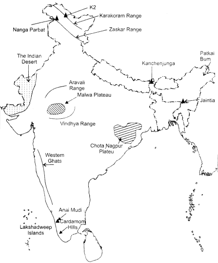
MAP SKILLS
On an outline map of India show the following.
(i) Mountain and hill ranges – the Karakoram, the Zaskar, the Patkai Bum, the Jaintia, the Vindhya range, the Aravali, and the Cardamom hills.
(ii) Peaks – K2, Kanchenjunga, Nanga Parbat and the Anai Mudi.
(iii) Plateaus, Chotanagpur and Malwa
(iv) The Indian Desert, Western Ghats, Lakshadweep Islands
Answer –
Leave a Reply